

Equipment & Software for Geophysical Surveys: Design, Manufacture, Support, Supply
UgCS - Drone flight planning software
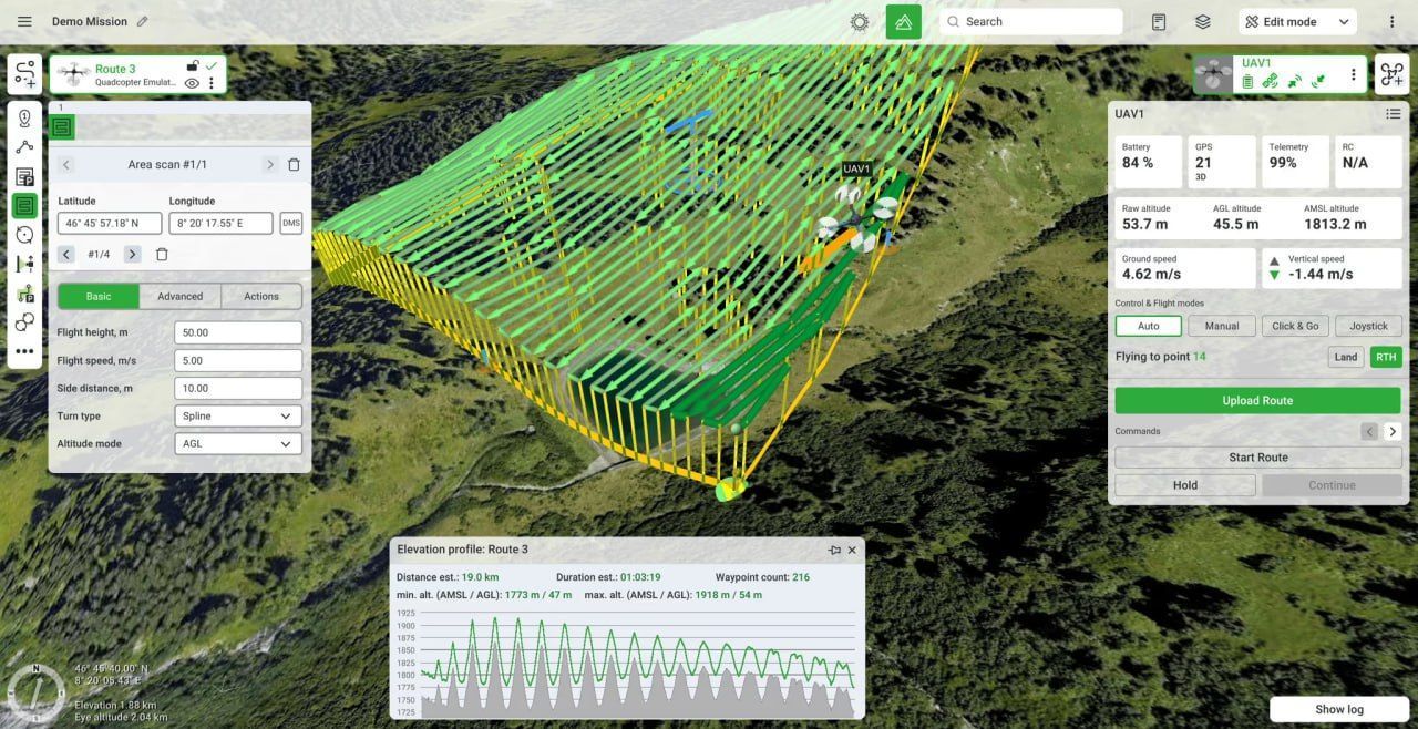
UgCS is a desktop-grade, multi-platform drone mission planning software designed for rigorous geospatial and survey workflows. It enables precise, automated flight planning—even in complex terrains—by supporting KML/CSV route imports, custom DEM data, terrain-following path creation, and offline map caching. The program’s clean and intuitive interface is designed to be easily understood by both beginner and professional UAV pilots.
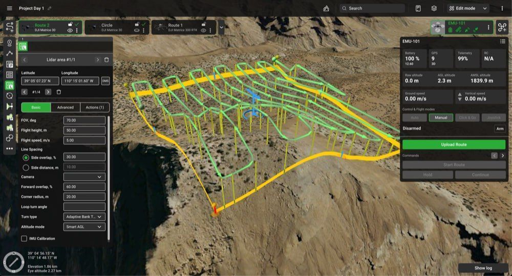
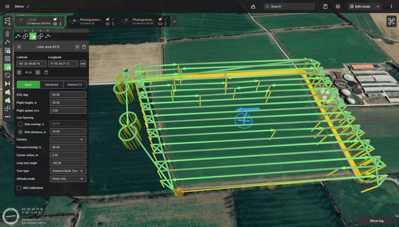
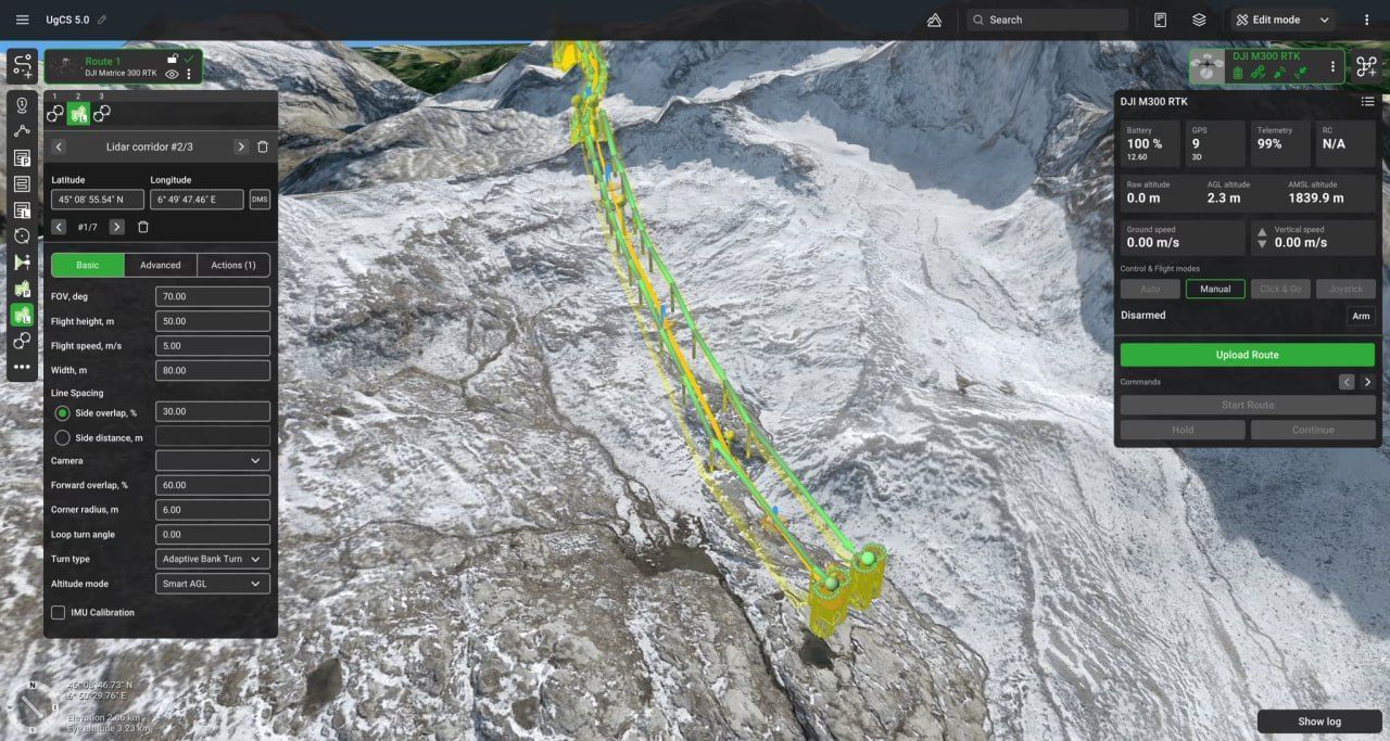
Built for professional workflows, UgCS features tools for photogrammetry, corridor mapping, vertical scans, LiDAR missions, and magnetometry surveys—all within a rich 3D planning environment. With compatibility across a wide array of drone platforms—including DJI, Freefly, Ardupilot/PX4, and more—UgCS offers exceptional flexibility.
Applications:
- LiDAR surveys
- Vertical inspections
- Mining
- Photogrammetry
- Magnetic and other low altitude surveys
- Powerline inspections
- Live video streaming surveys
- Test counter-drone systems
UgCS offers three license levels that scale with the operator’s needs. PRO provides all the essential tools for photogrammetry, mapping, and inspections, making it the optimal choice for most pilots. EXPERT extends functionality with specialized LiDAR tools and precision algorithms, enabling the collection of higher-quality data from the very first flight. ENTERPRISE unlocks the full potential of UgCS: centralized planning, multi-drone missions, video streaming, and SDK integration, making it the ideal solution for teams and large organizations.
Why choose UgCS PRO
- Preplan flights from home or office on a large screen
- Reduce time spent in the field by planning ahead
- Take on more complex projects and expand your drone operations
- Increase safety through advanced terrain following algorithms
- Use a single flight planning solution for all drones in your fleet
Why choose UgCS EXPERT
- Preplan flights from home or office on a large screen
- Reduce time spent in the field by planning ahead
- Smart AGL allows to fly up even near-vertical slopes
- Automate IMU calibrations to capture consistent LiDAR data
- Collect better LiDAR data from the first time
- Compatible with any LiDAR sensor on a drone
Why choose UgCS ENTERPRISE
- Centralize flight planning and telemetry for the drone fleet
- Plan flights in the office and share with drone pilots
- Deploy UgCS server in remote or local cloud
- Access and record live video feed from drones using video tools
- Scale your drone business by building custom apps through SDK
Often, drones come with their own flight control software. For example, one of the most popular enterprise UAVs from DJI is equipped with DJI Pilot 2, a native app designed for basic waypoint missions and simple inspections. However, when projects require advanced 3D planning, terrain-aware automation, or specialized workflows such as LiDAR and magnetometry surveys, operators turn to UgCS as a professional mission planning solution.
| Feature / Tool | DJI Pilot 2 | UgCS |
|---|---|---|
| FLIGHT PLANNING | ||
| Basic route creation | ✓ | ✓ |
| Suitable for large areas / complex projects | – | ✓ |
| Route customisation | Limited | Full |
| Number of planning tools | 4 | 12 |
| Automatic route from files | KML only | KML, CSV |
| Segments per route | Only 1 type at once | Unlimited |
| Preview multiple routes | – | ✓ |
| Circlegrammetry tool | – | ✓ |
| Vertical scan tool | – | ✓ |
| Orbit flights | – | ✓ |
| LIDAR FEATURES | ||
| DJI L1 / L2 calibration | ✓ | ✓ |
| Flight planning using FOV angle | – | ✓ |
| IMU patterns: 8 / U-shape | – | ✓ |
| Adjustable corner radius | – | ✓ |
| Loop corner turns | – | ✓ |
| TERRAIN FOLLOWING | ||
| Basic AGL following | ✓ | ✓ |
| Near-vertical slopes | – | ✓ Smart AGL |
| Elevation profile preview | – | ✓ |
| Adjustable AGL resolution | – | ✓ |
| MAP FEATURES | ||
| DEM import | ✓ | ✓ |
| Map overlays | ✓ | ✓ |
| Map display | 2D only | 3D available |
| Offline map caching | Map only | Map + Elevation |
| Display KML lines | – | ✓ |
| Visibility range preview | – | ✓ |
| Custom no-fly zones | – | ✓ |
| OVERVIEW | ||
| Platform | DJI RC Pro / Plus | PC / Mac |
| DJI drone support | M300, M350, M400, M30, M3E | + M600, M210, P4, M2 etc. |
| PX4 / Ardupilot support | – | ✓ |
| Collaborate with pilots | – | ✓ |
| Multiple drones control | – | ✓ |
| Centralized deployment | – | ✓ |
Supported Drones for UgCS
UgCS is compatible with a wide range of drone platforms.
- Acecore
- Arcsky
- Aurelia
- Autel
- CubePilot
- DJI (including Mavic, Phantom, Inspire, Matrice series)
- DroneBase
- Freefly
- Hexadrone
- Inspired Flight
- Other Ardupilot / PX4 (e.g. Pixhawk-based drones)
- Watts Innovations
- Wispr
- Xer Technologies
- Yuneec
| Feature / Tool | UgCS PRO | UgCS EXPERT | UgCS ENTERPRISE |
|---|---|---|---|
| Route creation from KML / CSV | ✓ | ✓ | ✓ |
| Export routes in KML (Google Earth Pro preview) | ✓ | ✓ | ✓ |
| Circlegrammetry tool | ✓ | ✓ | ✓ |
| Terrain following | ✓ | ✓ | ✓ |
| Customisable map overlays & DEM/DSM import | ✓ | ✓ | ✓ |
| Corridor inspections | ✓ | ✓ | ✓ |
| Vertical flight planning / Facade scan (3D models) | ✓ | ✓ | ✓ |
| Offline flights (cache maps & elevation) | ✓ | ✓ | ✓ |
| Smart AGL (fly near steep terrain safely) | – | ✓ | ✓ |
| LiDAR tools (Area & Corridor, IMU calibration, patterns) | – | ✓ | ✓ |
| Trajectory smoothing (for LiDAR & magnetometry) | – | ✓ | ✓ |
| DSM support in elevation profiles | ✓ | ✓ | ✓ |
| Live video streaming | – | – | ✓ |
| Up to 10 simultaneous drone connections | – | – | ✓ |
| Team collaboration (centralised UgCS server) | – | – | ✓ |
| UgCS SDK (build custom solutions) | – | – | ✓ |